|
TRANSLATIONS
|
Also H has its
parallel hupee in line a6, and here at the very end of the
line:
 |
 |
 |
 |
|
*Ha6-66 |
*Ha6-67 |
*Ha6-68 |
*Ha6-69 |
The following hipu indicates a 'break' between line a6
and a7:
 |
 |
 |
 |
 |
|
Ha7-1 |
Ha7-2 |
Ha7-3 |
Ha7-4 |
Ha7-5 |
 |
 |
 |
 |
 |
|
Ha7-6 |
Ha7-7 |
Ha7-8 |
Ha7-9 |
Ha7-10
(354) |
The glyph type
hipu exhibits the opposite characteristics of
hupee, a single hanging down 'fruit' instead of a
triplet of 'fingers' held high. The word hipu looks
like the result of hupee having been played around
with.
Furthermore,
there is a 'midnight' type of henua in Ha7-10.
Counting with 5 'invisible' glyphs in the burnt area in line
a6 its ordinal number becomes 12 * 29½ = 354.
Tagata in
Ha7-3 has a single mata sign as head. It could refer
to Sun - who is only half a 'person' because he is present
only during half the year. In the sacred geograhpy of the
island his presence probably is corresponding to the
northern coast, his absence to the southern coast.
Tagata in
Ha7-9 is drawn en face and with empty hands. The
elbow ornaments are like legs, the one at left fatter than
the one at right. It fits with my idea of a correspondence
between item 24 in the 2nd list of place names and hupee
in line a6 (of both Q and H). The season when Sun is present
brings affluence, the season of his absence brings hunger
(empty hands):
... Rehua
had two wives, the stars on either side of Antares. One
was Ruhi-te-rangi or Pekehawani, the
personification of summer languor (ruhi), the
other Whaka-onge-kai, She-who-makes-food-scarce
before the new crops can be harvested ...
The 'extra pair
of legs' at the elbows is a sign which presumably indicates
a change from one sequence in time to another. It could be
a sign adapted from the 'extra pair of arms'
in Indian iconography:
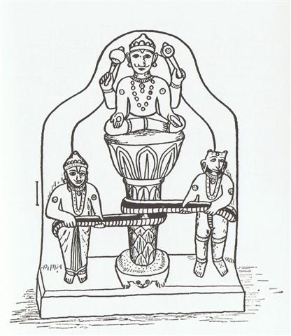
The right
hand of the central figure is not only open but also has a
'zero' sign. Is the left hand holding out a bread? The torso
seems to have 3 sun symbols (circles with 'pupils'). Also
the 'beast' (bottom right from us seen) and the man (bottom
left) have these triplets of sun symbols, which presumably
means all 3 figures are one and the same. They correspond to
the triplet of sun symbols.
|
|
If we could use the
sacred geography of Easter Island as a map for relating glyph
sequences in the rongorongo texts to 'stations' in the
2nd list of place names it would be of great value.
Probably the northern coast of the island represents the
'domain of Sun', the season when he is present, and when we have counted to
24 in order to reach 'ko ehu' (ashes) we should be at the end of his
season. Ancient traditions could have told about 24º
from the equator to the tropics.
Locating ko ehu
in the east instead of in the west (where Sun goes down in the
evening) rises an obstacle, but it can be overcome by assuming the islanders had a
method of using the position of full moon against the starry
sky to deduce the current location of sun on his path, i.e. a system
of lunar mansions which are 'reflecting' the stations of the sun.
Such a system was used in India and there the lunar mansions were
named nakshatras (from Sanskrit nakshatra = star).
If 24 stations
will cover the half year when Sun is present, then we will expect
midsummer to be at the 12th station, in the center of the northern
coast:
| 12
vai poko aa
raa mata
turu |
| 24
ko ehu ko mahatua a piki rangi a hakakihikihi mahina |
Presumably vai
is a technical term which means the 'fire' is extinguished. The 'eye' (mata)
of sun (raa) will descend ('drop') beyond midsummer:
|
Turu
To come down, to go down, to descend;
ka-turu-age koe ki tai, go down to the sea now;
turuga, coming down, descent. Vanaga.
1. To fall in drops, to flow, to leak,
to descend, a drop; turu ki tai, to take refuge
at sea; hakaturu, to cause to descend, to lower,
to take soundings; hakaturuturu, to heave and
pitch. Turuga, declivity. Turuvai, water
conduit. P Mgv.: akaturu, to conduct water in a
drain. Ta.: tuturu, to fall in drops. 2. To stay,
to prop. T Pau.: turu, a post, pillar, to
sustain. Mgv.: turu, a support, rod, stay, to
sustain. Ta.: turu, stay, support; turuturu,
posts of a house. Ha.: kukulu, a pillar, a post.
3. To come, to arrive, to overcome; tehe e turu,
through and through; hakarava hakaturu,
quadrangular. Churchill. |
Vai poko sounds as if it was alluding to Te Poko Uri
(according the 1st list of names), i.e. to Rano Kau:
|
Poko
1. Fragrant; to smell, to give off a
smell: he-poko te eo, it gives off a pleasant
smell. 2. To hunt, to catch with a trap, to snare.
He-kî e Tori: maaku-á e-ea ki te manu, e-poko i
te po i ruga i te opata. Tori said: I shall go
and catch birds at night, up on the cliff. 3.
Thunder (also hatutiri). 4. (Also:
pokopoko.) Hollow, hole, depression, any deep,
concave object; to leave in a hole, in a depression.
Pokoga, chasm; summit. Pokohata,
female rat: kio'e pokohata. Pokopoko,
woman bent under the weight of her years: vî'e
pokopoko. Vanaga.
1. Sound of the sea; tai poko,
breakers. Pokopoko, to slap water. Mgv.:
pokokina, resonant, clear-toned. Mq.: poko,
to slap the water in imitation of drumming;
pokokina, sound of water. 2. Rut, beaten path. P
Pau.: poko, hollow; pokopoko, concave,
to excavate. Mgv.: poko, to dig, to excavate,
to hollow out. Mq.: pokoko, to crack open;
pokona, to hollow out, to excavate. Ta.:
poópoó, hollow, deep. 3. Infernal; pokoga,
hell, infernal cave; topa ki te pokoga, to
damn (lit: to go down to hell.) Mq.: pokona,
cavity, hole. Churchill.
Pokopoko: 1. Womb. PS Sa.:
po'opo'o, clitoris. Mq.: pokopoko,
pudendum muliebre. 2. Pokopoko vae,
footprints. 3. Concave, deep, ditch, mysterious;
pokopoko ihu, nostril (Ta.: poópoó
ihu); pokopoko ke, fathomless;
pokopoko taheta, concave.
Hakapokopoko, to deepen. Chuchill |
Looking at glyph line Qa3 (halfway to Qa6) - guessing each line
covers 1 month - we find tahana
glyphs:
 |
 |
 |
 |
 |
 |
|
Qa6-30 |
Qa6-31 |
Qa6-32
(237) |
Qa6-33 |
Qa6-34 |
Qa6-35 |
 |
 |
 |
 |
 |
 |
|
Qa3-25 |
Qa3-26 |
Qa3-27 |
Qa3-28 |
Qa3-29 |
Qa3-30 |
 |
 |
 |
 |
 |
|
Qa3-31 |
Qa3-32
(98) |
Qa3-33 |
Qa3-34 |
Qa3-35 |
Sun is here shown growing (kai in Qa3-28 and Qa3-34) but
seemingly his growth is at its end (maro). The bottom
part of tahana in Qa3-26 is similar to that in hupee
in Qa6-32, and the number of the glyph for tahana in Qa3-32
agrees with the number for hupee in Qa6-32. 6 * 32 = 196
and 3 * 32 = 96. Maybe 32 was used to symbolize 'growth' (being
the 5th term in the series 2, 4, 8, 16, 32, 64 ...).
The rare tahana glyphs may be related to the rare hupee
glyphs. Once we have realized this, we can perceive a hupee
sign also in tahana in Ab5-23:
 |
 |
 |
 |
 |
 |
|
Ab5-21 |
Ab5-22 |
Ab5-23 |
Ab5-24 |
Ab5-25 |
Ab5-26 |
|
|
However, according
to Barthel 2 the 12th item in the 2nd list of names is not anywhere
near Anakena, the 'beach' of the king, although it lies
rather close to the center of the northeastern shore of the island:
"The 'deep watering
place' (wordplay, 'fragrant watering place') is located a short
distance south of Ahu Tepeu. Perhaps the additional name 'sun
with weeping eyes' is connected with the 'weeping-eye' motif painted
on dancing paddles ..."
Instead, the 12th
item evidently refers to a location on the western coast south of
Ahu Tepeu - where Tuu Ko Ihu the carver of the wooden
images (cfr at kava) lived:
Tuu Ko Ihu
we should also remember for buring the skull of Hotu Matua in
a very deep hole (at Ahu Tepeu). The technical term vai
for this place is understandable - the 'skull' goes down deep and
can definitely not be seen at the location of the 12th item.
... After Tuu Ko Ihu
had reached up with his hands, he cut off the skull and put it into
his basket. Out (went) the king, Tuu Ko Ihu, and ran to
Ahu Tepeu. He had the skull with him. King Tuu Ko Ihu dug
a hole, made it very deep, and let the skull slide into it. Then he
cushioned the hole with grass and put barkcloth on top of it,
covered it with a flat slab of stone (keho), and covered
(everything) with soil. Finally, he put a very big stone on top of
it, in the opening of the door, outside the house ...
The flat slab of
stone, keho, suggests a solstice, where the path of Sun (the
ecliptic) does not appear to bend at all:
| Keho
Flag-stone (which is plentiful in Rano
Kau and was used to build Orongo); stone
disc, used as a thrown weapon in wars. Vanaga.
Kehokeho, dry, arid. Kekeho,
to clot, to curdle, to coagulate; toto kekeho,
clotted blood. Churchill. |
| Kehu (cfr ehu)
Hidden; what cannot be seen because it is
covered; he-kehu te raá, said of the sun when it
has sunk below the horizon. Vanaga.
Kehu, hakakehu, to hide,
disguise, feint, feign, to lie in wait. Kekehu,
shoulder G. Churchill. |
The word is
similar to kehu (hidden), which in turn connects to ehu
(ashes), as if kehu 'originally' meant 'covered by ashes'.
Kekeho is coagulated blood, blood turned into a kind of dry (kehokeho)
earth.
To keep our model
intact, with the northern coastline corresponding to the season when Sun is present
on the island, we must count also the western coast as belonging to
this Sun-is-present season.
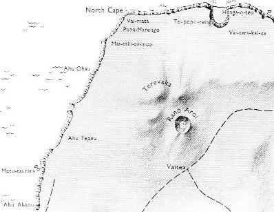
Looking again at
the available maps we can see that the orientation of the map above
is misleading. North is not straight up, which for instance this
overview from Van Tilburg shows:

Here we can also see
the 'political' areas with Ko Tu'u as a central mountain
determining a shore line in the north which we can guess corresponds
to our hypothetical Sun-is-present season.
Spring with its
vegetational growth will coincide with Sun 'eating' and coming
closer (the stretch from a point somewhere north of Hangaroa
up to the North Cape). Beyond high summer (the area around the North
Cape) Sun will slowly withdraw in proportion to how the coastline recedes
southwards.
Our new and improved
perspective of the island does not help much, though.
Vai poko aa raa mata
turu is not
in the center of Sun's journey from the equator up to Easter Island
and then back again. But its position could reflect the position of
Rano Kau,
if we place a mirror in between, maybe at
Hangaroa.
A solution to the
problem at hand can be found if we assume there are 20 stations for
Sun-is-present, because then the halfway station will be at item 24
- 10 = 14:
| 4
Okahu a uka ui hetuu. |
0 |
| 14
hatu
ngoio a taotao ika. |
10 |
| 24
ko ehu ko mahatua a piki rangi a hakakihikihi mahina |
20 |
The 14th item in
the 2nd list of place names is located 'close to Ahu Vai
Matā' according to Barthel 2, and this is exactly where we hope
it to be. The 'disoriented' map above has Vai-mata at the
North Cape of the island.
The ahu is not visible on the map,
but the locations (according to Barthel 2) of item 13 and item 15 as 'not far from Ahu Maitaki Te Moa' respectively
'an ahu and a cave east of Ana Heu' makes the
identification of item 14 exact and secure - item 14 represents the
'north cape of summer'.
We must, of
course, try to interpret the name hatu ngoio a taotao
ika in order to see that there are meanings which agree with
'our map', and also to gain more knowledge which might be
of value in reading the rongorongo texts. This endeavour
needs a set of separate pages.
|
|