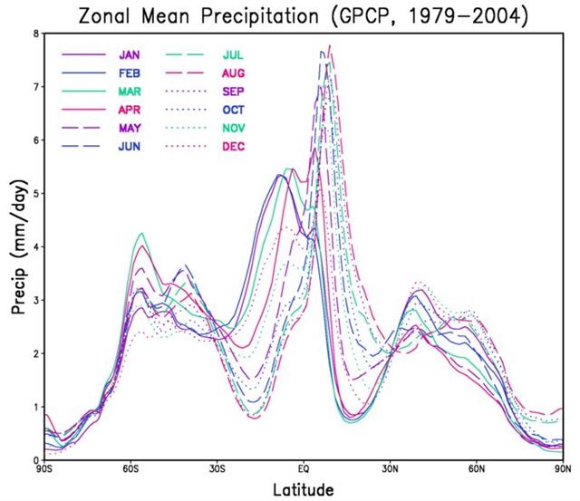
2. Rain falls primarily on the mountains, because the clouds are forced upwards when they encounter higher ground. The air pressure is lower at higher altitudes, which causes rain drops to condense from the moisture in the clouds. "In mountainous areas, heavy precipitation is possible where upslope flow is maximized within windward sides of the terrain at elevation which forces moist air to condense and fall out as rainfall along the sides of mountains." (Wikipedia) Looking quickly in Wikipedia for comments on the phenomenon of rain I found an informative diagram:
The distribution of rainfall over the year depends on latitude. On Easter Island (latitude 27º S) rain ought to fall rather evenly distributed over the year. However, moving towards the equator, closer to the center of Polynesia, we can see that April should be a month with heavy rainfall. At the equator April is the month with most rain. If we move ahead a further 4 months, we will reach August. The creator of the diagram has divided the year into tertials, and the curve of rainfall for August is the lowest of them all at central Polynesian latitudes. With Easter Island at a latitude where there should not be any greater seasonal change in the precipitation, they would have been free to rely on an ideal division of the year into tertials. Such a division ought to begin by defining April as a rainy month and August as a dry month. This suggestion fits beautifully with Hora Iti, the month at the beginning ('little', iti) of summer (hora):
And there is a quarter both from Vaitu nui and from Gb2-16 to the end of the year:
|


