The first part of the 2nd list of place names (up to Rano Raraku in item 29) apparently is structurally like the Hawaiian moon calendar. Below I have coloured red those nights for which was mentioned a low tide - which I translate by the theory of correspondences into a 'high coastline' in the 'sacred' geography of Easter Island:
For the 2 blackmarked nights (18 and 24) is noted a high sea level. For the blue nights neither a low tide nor a high sea level was mentioned. The high tides in nights 18 and 24 could have been 'underlined' in order to indicate the distance from midsummer (around day 180) to the end of the 'front side' (around day 240). 12 is in the 2nd list of place names where 'the fierce spring fire' is restrained - presumably stated by the technical term vai. A'a means 'to inundate' and vai poko aa raa could mean that water from the 'well' (poko) is 'quenching' the sun. It is the place where the 'tears' of sun are dropping (raa mata turu):
At item 24 only his ashes (ehu) remain. The season of piki rangi (rising sky) is over and moon (mahina) 'colours' the earth grey (hakakihikihi). Time is here - where the front side is turning into the back side (tu'a) - 'folded' (mahatu), expressed in wordplay by Makoi (or rather by the Old Ones) when giving its name as Mahatua (= mahatu + tu'a). The coastline in northwestern Easter Island is steep, marked as a broad line on the map:
Up to Cabo Norte this high coast moves north (towards the equator) in a way similar to how Sun in spring moves higher in the sky. This part of the island can therefore be identified as spring if the island is used as a map. It will then be an important part of the path of Sun over the year. But beyond Cabo Norte it seems to be the path of Moon which is 'engraved' in the geography. The Hawaiian Moon calendar has Laau-pau ('end', pau, of the 'tree', rakau), as night number 20. In the geography of Easter Island it corresponds to Hanga Ohiro, because the high coastline ends there. 20 nights, no more, should be counted in a month the Gilbertese said, and Hanga Ohiro is number 20 on the 2nd list of place names:
If the first night of a month is named Hiro (or Hilo as the Hawaiians said), then this high coastline ('ebb') will correspond to the nights up to waning moon ('flood'). The phase of growing spring sun is incorporated so to say as the first part in the calendar of the month. Sun and moon rise together up to Cabo Norte. Maybe we should think of a single calendar map to be used for both the month and the year? For instance:
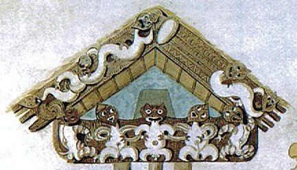
400 / 25 = 16, i.e. for each night of the calendar we can alternatively count 16 days in order to reach a year with 20 * 20 = 400 days. The last 4 nights (Kane - Muku) are 'ebb' items, and they belong to the 'front side' of next year. 4 * 16 = 64. Likewise, when counting the nights in a month we need to begin 4 nights earlier in order to reach 20 at night number 16 (Mahea-lani). However, we should not be fooled by Manuscripte E, nor imagine we have understood. The expression raa mata turu, e.g., will also fit with the apex of the Taranaki storehouse:
The terrified Sun King (Ra'a) at the top probably represents the end of spring and he will loose his head at the apex, at midsummer. It becomes an egg (mata - 'the source from which a thing originates') which moves downwards (turu) - though hidden for some time - to appear as his offspring later on. At left there is a front side with 3 fingerlike beams and beyond apex comes the back side (tu'a) with 4 beams. At bottom is the high sea and we can see the waves. |
||||||||||||||||||||||||||||||||||||||||||||||||||||||||||||||||||||||||||||

